The United States of America is composed of 50 states, each with its unique identity and abbreviations. Understanding these abbreviations is crucial for navigation, communication, and data analysis. The standard abbreviations for the 50 US states are established by the United States Postal Service (USPS) and are widely used across various sectors, including government, education, and commerce.
Primary State Abbreviations

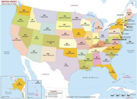
The primary state abbreviations are two-letter codes that represent each state. These codes are used for mailing purposes, data entry, and other applications where brevity is essential. The list of primary state abbreviations includes:
| State | Abbreviation |
|---|---|
| Alabama | AL |
| Alaska | AK |
| Arizona | AZ |
| Arkansas | AR |
| California | CA |
| Colorado | CO |
| Connecticut | CT |
| Delaware | DE |
| Florida | FL |
| Georgia | GA |
| Hawaii | HI |
| Idaho | ID |
| Illinois | IL |
| Indiana | IN |
| Iowa | IA |
| Kansas | KS |
| Kentucky | KY |
| Louisiana | LA |
| Maine | ME |
| Maryland | MD |
| Massachusetts | MA |
| Michigan | MI |
| Minnesota | MN |
| Mississippi | MS |
| Missouri | MO |
| Montana | MT |
| Nebraska | NE |
| Nevada | NV |
| New Hampshire | NH |
| New Jersey | NJ |
| New Mexico | NM |
| New York | NY |
| North Carolina | NC |
| North Dakota | ND |
| Ohio | OH |
| Oklahoma | OK |
| Oregon | OR |
| Pennsylvania | PA |
| Rhode Island | RI |
| South Carolina | SC |
| South Dakota | SD |
| Tennessee | TN |
| Texas | TX |
| Utah | UT |
| Vermont | VT |
| Virginia | VA |
| Washington | WA |
| West Virginia | WV |
| Wisconsin | WI |
| Wyoming | WY |

Key Points
Key Points
- The United States Postal Service (USPS) establishes the standard abbreviations for the 50 US states.
- These abbreviations are crucial for navigation, communication, and data analysis.
- Primary state abbreviations are two-letter codes used for mailing purposes and other applications.
- Understanding state abbreviations is essential for various sectors, including government, education, and commerce.
- The use of standard abbreviations ensures consistency and clarity in communication and data representation.
Historical Development of State Abbreviations

The development of state abbreviations has evolved over time, reflecting changes in communication needs and technological advancements. Initially, state names were written in full, which was time-consuming and space-intensive. With the advent of postal services and the need for efficient communication, abbreviations became necessary.
The early abbreviations were not standardized and varied across different regions and applications. However, with the establishment of the USPS, a standardized system of abbreviations was developed to facilitate mail sorting and delivery. Today, these abbreviations are widely recognized and used across the United States.
Technical Specifications and Contextual Explanation
Technical specifications for state abbreviations are straightforward, with each state assigned a unique two-letter code. These codes are used in various applications, including mailing addresses, data entry, and geographic information systems (GIS). The use of standard abbreviations ensures consistency and accuracy in data representation and communication.
In the context of GIS and mapping applications, state abbreviations are crucial for spatial analysis and data visualization. They enable the efficient representation of geographic data and facilitate the analysis of spatial patterns and trends. Furthermore, state abbreviations are used in various data formats, including CSV, JSON, and XML, to represent geographic locations and attributes.
Practical Applications and Real-World Examples
State abbreviations have numerous practical applications in real-world scenarios. For instance, in logistics and transportation, state abbreviations are used to efficiently route packages and shipments. In data analysis and research, state abbreviations facilitate the representation and analysis of geographic data, enabling insights into demographic trends, economic patterns, and environmental phenomena.
In education, state abbreviations are taught as part of geographic literacy, helping students understand the layout of the United States and the relationships between different states and regions. Moreover, state abbreviations are used in various digital applications, including online mapping platforms, GPS navigation systems, and social media platforms, to represent user locations and facilitate geographic-based services.
Forward-Looking Implications and Emerging Trends
The use of state abbreviations will continue to evolve, reflecting advances in technology and changing communication needs. With the increasing adoption of digital technologies and the growth of geospatial data, state abbreviations will play a critical role in facilitating data analysis, visualization, and decision-making. Moreover, emerging trends in location-based services, smart cities, and the Internet of Things (IoT) will further emphasize the importance of standardized state abbreviations in representing geographic locations and attributes.
In conclusion, state abbreviations are a fundamental component of geographic representation and communication in the United States. Understanding these abbreviations is essential for various sectors, including government, education, commerce, and logistics. As technology continues to advance and communication needs evolve, the significance of state abbreviations will only continue to grow, facilitating efficient data representation, analysis, and decision-making.
What is the purpose of state abbreviations?
+State abbreviations are used to efficiently represent geographic locations and attributes, facilitating data analysis, communication, and navigation.
Who establishes the standard state abbreviations?
+The United States Postal Service (USPS) establishes the standard state abbreviations.
What are some practical applications of state abbreviations?
+State abbreviations have numerous practical applications, including logistics, data analysis, education, and digital applications, such as online mapping platforms and social media platforms.
Meta Description: Discover the significance of USA state map abbreviations and their practical applications in various sectors, including government, education, commerce, and logistics. Learn how state abbreviations facilitate efficient data representation, analysis, and communication. (149 characters)